Thursday 30 April 2009

Franz Josef and through to Nelson


Franz Josef is a small town on the west coast of South Island, arriving there by the usual mode of transport, the Atomic Shuttle bus, was both cheap and fairly cheerful. I decided to fulfil one of my lifetime ambitions of a helicopter ride, with, in this location, the opportunity to go hiking on the Franz Josef Glacier can be combined. The whole experience was unforgettable and added to the experience the weather was perfect, with clear skies and not too cold even on the glacier! Hard to beat the experience but the next day went on a three and a half hour 'tramp' on a local hike where the good weather held and I met a Finnish girl for company at the tail end of the hike. The day finished with a relaxing bathe in the glacial hot spring pools on the edge of town where I managed to ease all the lactic acid out of my weary and quite sore calf muscles. After 3 nights at the YHA in Franz Josef I returned to Greymouth (the cap fits the name here) and took part in a tour of the local brewery, Monteiths, and had a fine sampling of their many brew varieties, alongside a couple from Bristol, who agreed with my analysis of the beer as being too cold but otherwise as good as many English beers. After the tour we had a buffet dinner in the local hostelry, all for 6$, with a further sampling of Monteiths, but in larger amounts!
After one night in Greymouth I headed to Arthurs Pass, in the mountainous Southern Alps, central South Island. By the time I arrived at 10am the weather had greatly deteriorated and continued in the same vein for the next 36 hours, with torrential rain and very poor visibility. Predictably the local DOC centre advised against any hiking on the high paths, so over the next 24 hours I undertook one to one and a half hour walks on local paths into the bush and visiting the local waterfall, the Devils' Cauldron, aptly named and in full spate, so very dramatic and worth the soaking. Fortunately the YHA had a convenient drying room so no problem drying all my gear, but it did confirm that my hiking boots had developed a leak which I had repaired in Christchurch 2 days later. Spent much of the time catching up on reading and visiting the cafe next door which served very good coffee. I had pre-booked the Tranz Alpine train to Christchurch, on various peoples recommendation but the weather prevented the passengers from seeing very much, other than the fact that the rivers were beginning to rise with the heavy rainfall. Next day Greymouth (west coast)had severe flooding in the town and some roads to Christchurch (east coast) were closed due to raised river levels.
It was good to be back in Christchurch, where I spent 3 nights, at the same YHA, Rolleston House, situated near the town centre. Sadly the weather caught up with me on the second day when the ride in the gondola and Port Hills walk were a washout though I managed to get a full refund, so a free gondola ride.... The weather stopped me from going bellringing at Papanui, by local bus, which didn't arrive and I had another soaking! However all was not lost as I was able to go to the theatre and see a new comedy "The God of Warm Beer", funny, but definitely an 'X' rated play with some pretty bad language though I'd been warned by the ticket office and decided to take the risk.
The final stopping off point in South Island was Nelson, where I made plans to do my last 'great walk' in the south, the Abel Tasman Walk, primarily a coastal walk this time. This takes up to 5 days and DOC gave the weather the OK so after one and a half days in Nelson I would start this walk on the 2nd May. Nelson is an attractive town that reminded me of Queenstown without the high prices, and the YHA one of the better ones. The cathedral has a ring of 8 chimed bells and when I return from the tramp will go and have a look. Also was able to sample the swimming pool, and get more dive training practice.
The photo's this time are in random order, so keep that in mind when viewing!
Photo 1. A Moari street musician in Nelson High street.
Photo 2. Nelson Cathedral, a surprisingly modern building with chimed bells. The organist was playing during my visit and she agreed to play the fugue she was playing for morning service on the following Sunday, as well as giving me details of the steeple keeper.
Photo 3. The Devils' Cauldron, Arthurs Pass.
Photo 4. The west coast and the Tasmin Sea near Greymouth.
Photo 5. Franz Josef River of waters draining from the glacier.
Photo 6. Post glacial hike lunch with fellow hikers.
Photo 7. Exploring one of the many glacial crevices with our excellent glacier guide.
Photo 8. Walking on glacial ice, once adapted to wearing crampons it became much easier.
Photo 9. The great height of some of the ice flows.
Photo 10. Landing and walking on the ice before putting on crampons was tricky!
Photo 11. The first view of the glacier from ground level.
Photo 12. View of the glacier as the helicopter came in to land on the ice.

Thursday 23 April 2009

Nurses Hiking in the Mount Cook National Park


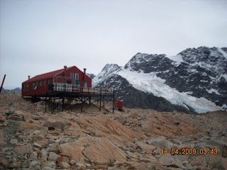
I arrived in Mount Cook Village in the early afternoon of the 16th April having again met Meeake, a young Danish nurse, whom I met on one of the days of the Kepler Walk, two weeks previously. We were quickly joined by an Italian nurse, living in Zurich, as well as a Japanese girl from Osaka, and, despite the persistant rain, went walking on 3 of the local 2-3 hour long hikes over the next two days. The local office of the Department of Conservation (DOC) advised the weather would be very wet until our third day when we decided to go for one of the toughest hikes in the area, the Mueller Hut hike. We had been warned, and no one exaggerated, it was harder than the Everest Base Camp trek. The terrain was tough, particularly the last 100 metres of the 1100 metre climb, climbing a steep scree face (3 steps forward and 2 back) however the panorama on reaching the summit was worthwhile and having lunch in the Mueller Hut sitting outside on the verandah with views of the Mueller glacier and the added spectacle of snow avalanches roaring down the mountain side opposite onto the glacier was a dramatic site indeed.
This 'tramp' was fittingly ended in the local bar where I was able to sample some Speights beer one of the south island local brews, my only reservation being the temperature - too cold, but nevertheless an entertaining evening. The next morning I journeyed by bus to Wanaka, for one night, before a journey to Greymouth, on the west coast of south island.
Photo's are yet again in reverse order...
Photo 1. Sampling the local brew with the intrepid crew, including Dow, the very kind Canadian who waited patiently for 2 hours for us to finish the tramp, and then drove 3 very tired girls to the local bar.
Photo 2. The Mueller Hut at 1400 metres. This was the 4th hut built here in the past 60 years, others were swept away in avalanches. All the components for this were helicoptered to the summit, 150m higher, and brought down by sled.
Photo 3. 2 of 3 nurses and Japanese friend on the swing bridge on the way up to Red Tarns on Day 2 of the Mount Cook Village stay.
Photo 4. The Mueller Glacier viewed from the hut.
Photo 5. Taking a rest break on the long climb with a view of Mount Cook in the background. Apparently Edmund Hillary gained much of his climbing experience on this peak before climbing Everest.
Photo 6. Mount Wakefield viewed from Mount Cook village.
Photo 7. Mount Cook with the Hooker Glacier and lake (with icebergs) in the foreground, taken as we climbed the Mueller Hut tramp.

Tuesday 14 April 2009

Dunedin the Edinburgh of New Zealand


Arriving in the city on Wednesday 8th April was in way of a contrast to Te Annau and Queenstown in that the city is not only larger but despite its' close location to the Pacific with attractive landscapes all around the city, and is more of an industrial city with some poorer neighbourhoods. The YHA is situated in one such neighbourhood in an old hospital, and is an attractive building with many nooks and crannies. The city has close connections with Scotland with many of the early settlers from Scotland and is built on a series of hills, boasting one of the steepest streets in NZ.
I rang the bells at the First Church of Otago, a presbyterian church, on Easter Sunday, a light ring of 8 bells. The treble is the bell situated furthest south of any bells, a good bell to ring but requiring a light touch. The ringers made another visiting English ringer and myself very welcome.
I stayed in Dunedin longer than originally planned due to the problem of having to wait for my new credit card to arrive from England, combined with the Easter weekend it took 7 days. The compensation was that I found a great olympic standard swimming pool with a diving pool which enabled me to continue training for the dive course in July/August in Australia. Also found a local train which followed the coast for a return 3 hour journey, sadly I assumed it was a steam train but as you can see from the picture the engine was a deisel but the carriages were from the late 19 and early 20th centuries, something of a compensation!
The second journey from Dunedin was a wildlife tour to the only mainland albatross colony on the peninsula, sadly the conditions were too calm for the adult albatross' to land and feed their chicks but we were able to see the chicks from the hide at the centre, but we visited a private beach near the peninsula and were able to see penguins and sea lions. We were able to walk within about 15 feet of both animals.
Photo's are shown , yet again in reverse order!
Photo 1. The Botanic Gardens, Dunedin. As with all similar gardens in NZ this is a fine example of the genre.
Photo 2. Octagonal telephone box in Dunedin main square, The Octagon, note the cathedral in the background (no bells).
Photo 3. Hooper Sea Lions on the beach at the peninsula, not chased this time.
Photo 4. A tame yellow eyed penguin, as with all the 10 or so penguins seen this one was walking away from the beach and would spend the night up on the hillside overlooking the beach, hidden amongst the low shrubs, away from his fellow penguins. These are not a sociable penguin, unlike the king penguins etc.
Photo 5. An albatross chick, sadly I was unable to get a clearer picture from the hide.
Photo 6 and 7. The view of the coastline from the train.
Photo 8. The deisel engine pulling the 'classic carriages', somewhat disappointing as expected a steam train!
Photo 9. The 'classic' carriage(s).
Photo 10. The sea lion on St Kilda beach, this one chased me, I ran.
Photo 11. St Kilda Beach, a great walk of about 6 km, a friend dropped me at the city cemetery, the furthest point from Dunedin.

Thursday 9 April 2009


Stayed in Te Annau for 2 nights before setting out on the Kepler Trek. Cheated a bit ( about 10 kilometres off the total trek of 60km to be precise)and took the water taxi speedboat to Brod Bay and started walking from there, more fun that taking the shuttle bus. The first day was spent climbing about 850 metres uphill through rainforest, which I completed in 2 hours. The first hut took three and a half hours and I was joined by 3 fellow YHA trekkers, Mike, Luke and Nathan who persuaded me to climb Mount Luxmore, a further 250 metres, as it was still only mid afternoon amd perfect weather.
The effort was well worthwhile, the views over the lakes and mountains fantastic. Though very tired we played the usual card games (!) before collapsing into the bunks. The next day was even better, and we all made an effort to be up and see the sunrise. The remaining incline of 300 m brought us to the Jackson Peaks, walking across the peaks, with narrow ridges and steep drops either side for about 2 km required much concentration, people had been known to cross on their hands and knees in windy conditions! The first 4 hours of the 6 hour trek were above the treeline in the sub-alpine region, and the panoramic views awesome(sic). The final 2 hours were a steep descent through the rainforest to the Iris Burn hut at the base of the long decline, situated near a waterfall and deep bathing pool on the river. This was one of the few times were I declined the opportunity to swim since leaving England, but was completely without any energy at the end of 6 hours trekking.
The next day was a 6 hour tramp to the Moturua Hut, mainly through rainforest with some clearings where I ate lunch perched on rocks. The flat terrain was easy walking and I arrived at the hut before the others to be greeted by a scene of chaos and kids. Apparently as the hut was nearest to the Rainbow Reach exit, by 2 hours, and had been booked out by about 8 families with a total of 16 children - all under 8. The families made the trampers, 6 in total, feel very welcome and plied us with food and joined us for a new card game patiently explained to us all by an Israeli couple. Before the evenings games we swam in the lake and retreated to the beach to light a fire and read our books in relative peace! Needless to say the nights sleep was disturbed by bumps and bangs from the large bunkroom upstairs and the sound of heavy rain on the corrugated roof, not the best nights sleep ever.
Two of us set off for the last 2 hours of the trek in heavy rain, the other two went on ahead. We had a lift from one of the families at Rainbow Reach the 12 km into Te Annau. Signing in at the YHA again Mike and I went to view the 1/2 hour movie of the Fjiordland area filmed by a local helicopter pilot and his friends, so good that I bought the DVD. We met the others for dinner at the local pizza hut (buying in BYO wine) and celebrated a superb walk before we all went our separate ways.
I stayed in Te Annau for a further day, partly to sort out my credit card which had been stopped as it had been fraudulently used (in the UK!. Fortunately MINT were very quick to pick this up. Also I needed some time to relax and recoup after the trek. The next move was to Dunedin via a night in Queenstown, with the aim of ringing the bells at the 8 bell tower in the city with luck for Easter Sunday.

Photo 1. Atop Mount Luxmore
Photo 2. Sunrise from near the Luxmore Hut
Photo 3. First view of Lake Te Annau on from the Kepler Track
Photo 4. View of the Murchison Mountains from the beginning of the Jackson Peaks
Photo 5. Another kilometre or so along the Kepler looking at the the Murchison Mountains
Photo 6. Nearing the end of the Jackson Peaks and the view of the Kepler Mountains
Photo 7. The first sight of the rainforest on the decline to Iris Burn Hut. NB the tree line is clearly defined.
Photo 8. Moving down through the forest and glimpses of the mountain peaks where we climbed down.
Photo 9. The beginning of the rainforest at the treeline.
Photo 10. The great density of the rainforest and the presence of mosses and lichens is an indicator of the lack of pollution here.
Photo 11. The waterfall near Iris Burn Hut.
Photo 12. Iris Burn Hut as with all the huts had cold running water, flushing loos and gas for cooking. Food for 3 days and utensils were in our backpacks.
Photo 13. First views of Lake Motorua and beach.
Photo 14. Repeat of photo 9!!
Photo 15. The forest between Moturua and Rainbow Reach, where the forest is less dense.
Photo 16. Luke and me grabbing some peace and quiet from the noise and crowds in Motorua Hut
Photo 17. The river from Lake Moturoa to Lake Te Annau. This river was used in the Lord of the Rings, and named the Anduin River.
Photo 18. The farewell dinner at the Pizza restaurant in Te Annau. Left: Mike and me, Right: Luke and Nathan. A blindingly funny evening!